If you have been dreaming of a true wilderness adventure in the heart of the Great Barrier Reef, the newly constructed Ngaro Track is set to become Australia's most talked-about hiking experience. Open for the 2026 season, this spectacular 32-kilometre, three-day trail on Whitsunday Island blends rugged coastal scenery, ancient cultural heritage and remote island wilderness into one genuinely unforgettable experience. Whether you are a seasoned multi-day hiker or planning your first serious trek, this guide covers everything you need to know — from the Ngaro Track map and trail grades through to Ngaro Track bookings and the best Hamilton Island accommodation for your post-hike recovery.
Table of Contents
1. Hike Overview
2. Trail Difficulty and Terrain
3. Ngaro Track Map Highlights
4. Scenic Highlights Along the Track
5. Wildlife and Flora to Expect
6. Recommended Gear and Preparation
7. Best Times to Hike the Ngaro Track
8. Ngaro Track Visit Requirements and Bookings
9. Campsite Facilities on the Trail
10. Practical and Safety Tips for Your Hike
11. The Broader Ngaro Sea Trail
12. Why Hamilton Island is Your Perfect Ngaro Track Base Camp
13. Book Your Pre and Post-Hike Accommodation Today
14. Frequently Asked Questions About the Ngaro Track
Hike Overview
The Ngaro Track is a 32-kilometre, three-day hike located entirely on Whitsunday Island — the largest island in the Whitsundays archipelago, sitting just across the water from Hamilton Island. Newly constructed and officially open for the 2026 season, the trail is only accessible by boat, giving it a genuinely remote feel that most Australian walking tracks simply cannot match. It was thoughtfully co-designed with the Ngaro People, the Traditional Owners of the Whitsundays, whose deep connection to this land and sea Country spans thousands of years. The trail winds through the Great Barrier Reef World Heritage Area, offering a profound way to experience the natural and cultural significance of the Whitsunday Islands National Park.
Location and Access Points
Whitsunday Island is a separate, largely uninhabited national park island — distinct from Hamilton Island, which is the resort island most visitors are familiar with. The track has two vessel access points: the official trailhead at South Whitehaven Beach on the island's eastern side, and the finish point at Tongue Bay near Hill Inlet on the northern end. There is no road or bridge access — a boat transfer is the only way in. Hamilton Island is the closest and most practical departure point, with several independent tour operators and private charter services offering regular transfers to Whitehaven Beach.
Important - confirmed by ngarotrack.com.au: The official Ngaro Track website notes that marine transfer schedules are dependent on tides and weather and may change without notice. Always confirm your departure timing with your charter operator well before your start date and build flexibility into your travel plans. As the closest accommodation to the trailhead, the HIPA team can point you toward reliable local charter operators when you book.
Trail Difficulty and Terrain
Grade Overview
The Ngaro Track is a genuinely challenging multi-day hike best suited to walkers with prior trekking experience and a solid level of fitness. Trail grades vary significantly across the three days — Grade 3 sections are sometimes rough with short steep hills, Grade 4 terrain is consistently rough and steep, and the Grade 5 stretch around Whitsunday Craig is rough, steep and partially unmarked, requiring confident navigation skills. Independent walkers must carry two reliable forms of navigation.
What to Expect Underfoot
The first day begins on the soft silica sand of Whitehaven Beach before transitioning into dense mangroves and coastal wetlands. As you gain elevation on Day 2, the landscape shifts into shaded woodland and ancient rainforest. By the time you approach the Whitsunday Craig summit — at 353 metres the highest point on the track — you are moving through rugged rocky highland heath with sweeping views in every direction. No two hours of walking feel the same.
Ngaro Track Map Highlights
The full route runs from South Whitehaven Beach in the south to Hill Inlet and Tongue Bay in the north across three days of hiking. Daily distances range from 8 to 12 kilometres. Download the official trail map PDF before departure and save it offline — mobile coverage on the island's interior is severely limited to non-existent.
Day-by-Day Route Breakdown
Day 1 - 8.3km, approx. 5 hours: South Whitehaven Beach to the Whitehaven Beach lookout, continuing past Theos Point and Chance Bay before finishing at Camp Site 1, known as Bowarri yamba or Moon camp.
Day 2 - 10.8km, approx. 7 hours: The most challenging leg. Bowarri yamba to the Bari Dhili and Bilbili dhili viewpoints, then up to the Whitsunday Craig summit and through Gumi (the Ponds) before resting at Camp Site 2, known as Dhula yamba or Tree camp, near Torres Bay and Herald Bay.
Day 3 - 12.8km, approx. 8 hours: A spectacular finish. Dhula yamba to the Murmuru bari (Round rock) viewpoint, then on to the famous Hill Inlet lookouts and finally down to Tongue Bay where the track concludes at the northern tip of Whitsunday Island.
Scenic Highlights Along the Track
Whitehaven Beach - consistently rated among the best beaches in the world - provides an iconic starting point that sets the tone for everything that follows. The Whitsunday Craig summit on Day 2 delivers a full 360-degree panorama across the Coral Sea and the surrounding Whitsunday Islands chain. The Day 3 Hill Inlet lookouts offer what is arguably the most photographed coastal view in Australia - the swirling white silica sands and electric turquoise waters. A unique highlight is the elevated mangrove boardwalk crossing the upper reaches of Hill Inlet, giving hikers a perspective that the vast majority of Whitsundays visitors never experience. In the evenings, the Bowarri yamba campsite perched on its rocky ridgeline provides spectacular sunset views over the Coral Sea.
Wildlife and Flora to Expect
Wildlife
Expect native wallabies, goannas and majestic sea eagles throughout the trail. From elevated coastal sections, keep a close eye on the surrounding Coral Sea for reef fish, dolphins and sea turtles. Observe all wildlife from a respectful distance and never feed them. The official track safety guide also flags venomous snakes — including death adders — as present on the track. Stay on marked trails at all times and wear appropriate footwear.
Flora Across the Elevation Zones
At sea level you will walk through resilient beach spinifex and low coastal shrubs. Moving into the interior, the vegetation gives way to dense ancient rainforest. Near the Whitsunday Craig summit, hardy highland heath takes over — a completely different landscape from the beach you started on. Stinging trees are present and cause extremely painful contact — stay on the marked trail at all times. All of these environments are managed in close partnership with the Ngaro People as part of their enduring custodianship of this land and sea Country.
Safety note — confirmed by ngarotrack.com.au: The official track website lists crocodiles among the environmental hazards in tropical waters near the track. If you are planning to cool off near Hill Inlet at the end of Day 3, be aware that Galnar Inlet — directly opposite Hill Inlet — has local reports of crocodile sightings. Do not swim at Galnar Inlet. This is easy to overlook when you are focused on the famous Hill Inlet views just across the water.
Recommended Gear and Preparation
Proper preparation makes the difference between an enjoyable adventure and a genuinely difficult experience. All items below are drawn from the official ngarotrack.com.au compulsory packing guide.
Compulsory Kit
Footwear: Sturdy hiking boots with solid ankle support are non-negotiable. Trail runners are not adequate for the Grade 5 sections around Whitsunday Craig.
Water and Hydration: A minimum of 3 litres per person per day is required. All water at trail points must be treated or filtered before drinking — carry a lightweight filter or purification tablets.
Sun Protection: High-SPF sunscreen, a wide-brimmed hat and a long-sleeved UV shirt are essential. Stinger suits are listed as compulsory on ngarotrack.com.au if you intend to swim — particularly important in the shoulder months of April, May, September and October when ocean temperatures can exceed 27°C.
Insect Repellent: An absolute must, particularly for the mangrove sections on Days 1 and 2.
Rain Gear: A waterproof outer shell is compulsory per the official packing guide. Tropical squalls can arrive quickly on exposed ridgelines.
Camping and Food: Independent hikers must carry a full camping kit, fuel stove and all food for three days plus one spare day's supply in case of boat transfer delays. Guided and catered hikers should confirm inclusions with their operator.
Navigation: Two reliable forms of navigation are compulsory. A personal locator beacon (PLB) is also compulsory — at least one per group of four — as mobile coverage is non-existent on much of the island's interior.
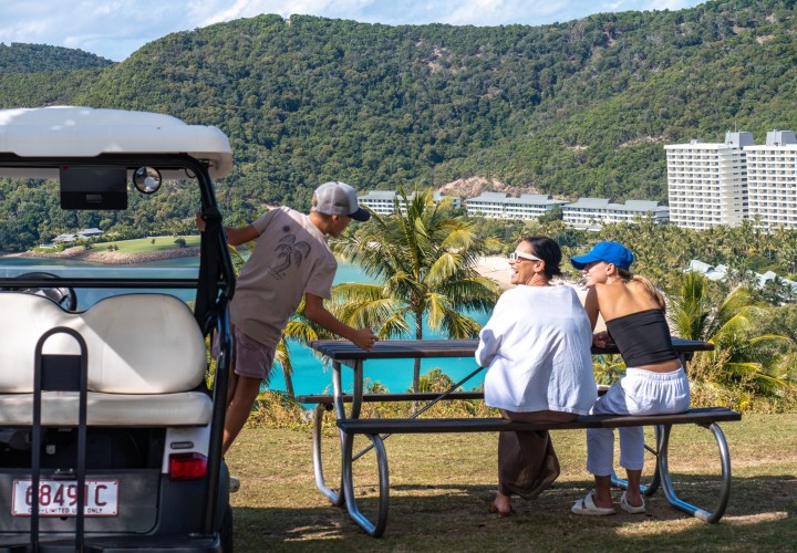
Post-Hike Recovery: After three days on a remote trail, returning to a self-contained HIPA apartment — complete with a full kitchen, private laundry and a complimentary buggy — is a dramatically better recovery option than a standard hotel room.
Best Times to Hike the Ngaro Track
The official season runs from April to October only. The track is strictly closed from November through to March due to extreme heat, the tropical wet season and the real risk of cyclones across the Whitsundays.
Month-by-Month Breakdown
April – May: Cooler and quieter with wildflower displays in the highland heath sections. Ocean temperatures are warm — stinger precautions apply from October through May.
June – August: Peak season with ideal dry conditions and the lowest marine stinger risk of the year. Limited to 15 walkers per day — book well in advance.
September – October: Warm shoulder season with slightly more availability. Stinger risk increases through October.
Worth knowing: Even within the April–October season, a cyclone anywhere in Queensland — even as far away as the Northern Territory — can cause flight cancellations and disruptions to Hamilton Island. Staying on Hamilton Island rather than the Airlie Beach mainland puts you in a far better position to manage last-minute weather changes without the added stress of travelling from the mainland to reach your boat transfer.
Ngaro Track Visit Requirements and Bookings
Because of the sensitive environment of Whitsunday Islands National Park, strict Ngaro Track visit requirements are in place. A full multi-day booking is absolutely mandatory — there is no day-use access, no partial access and no walk-in option. Access is limited to a maximum of 15 walkers per day to preserve the quiet, low-impact experience.
Your Three Booking Options
Fully Guided and Catered: Expert local guides provide cultural insight and safety support throughout, and all meals are prepared for you. Ideal for less experienced hikers or those who want to focus entirely on the experience.
Guided: You carry your own gear but benefit from professional guidance for navigation, safety and cultural context. A strong middle ground.
Independent: For experienced, self-sufficient hikers who prefer to move at their own pace. Full responsibility for navigation, food, safety and emergency equipment rests with you.
Book through the official partner World Expeditions: ngarotrack.com.au. For regulatory information visit the Queensland Parks and Wildlife Service.
Campsite Facilities on the Trail
At the end of Days 1 and 2, you will rest at purpose-built campsites designed to minimise environmental impact. Facilities include raised tent platforms (no ground camping permitted), communal shelters for cooking and socialising, and eco-friendly compost toilets known as "loos with a view" for their scenic positioning. Water tanks are available at both campsites but must be treated before drinking. No fires permitted — fuel stoves only. All rubbish must be carried out.
The Two Campsites
Camp Site 1 — Bowarri yamba (Moon camp): Perched on a rocky ridgeline at the end of Day 1. Elevated Coral Sea views and a welcome cool ocean breeze — one of the more memorable overnight spots in Australia.
Camp Site 2 — Dhula yamba (Tree camp): Located near Torres Bay and Herald Bay in a more sheltered, tranquil forest setting. After the intensity of Whitsunday Craig, the calm here feels well earned.
Practical and Safety Tips for Your Hike
Start at dawn each day: The tropical sun becomes punishing by mid-morning. An early start beats the heat and maximises afternoon rest time at camp.
Carry a PLB: Compulsory for all groups (at least one per group of four). Mobile coverage is non-existent on much of the island's interior - in a remote emergency it is your most reliable way to call for help.
Respect cliff edges: Several unfenced cliff edges exist near the Whitsunday Craig summit. Stay on the marked trail and exercise extra caution in wet or windy conditions.
Monitor weather daily: Check the Bureau of Meteorology forecast before each day's walk. Conditions can change quickly on exposed ridgelines.
Tell someone your itinerary: Always share your complete plan - campsites, daily route and expected return date - before leaving Hamilton Island.
Boat Transfer Tips
Confirm departure and return times with your charter operator before you set out. The official Ngaro Track website confirms that marine transfer schedules are dependent on tides and weather and may change without notice - build flexibility into your plans and always carry an extra day's food in case of delays. The HIPA team can recommend reliable independent charter operators from Hamilton Island — ask us when you book your accommodation.
The Broader Ngaro Sea Trail
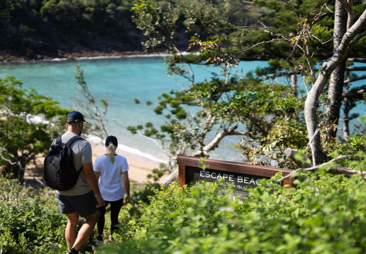
The Ngaro Track sits within the broader Ngaro Sea Trail network, which offers shorter walking experiences across multiple Whitsunday Islands. A compelling alternative is the Ngaro Cultural Site track on nearby Hook Island — a 20-minute walk to a cave featuring ancient Indigenous rock art, one of the oldest cultural sites on Australia's east coast, accessible by boat from Hamilton Island.
For walks closer to home, explore all of Hamilton Island's walking options in our dedicated Hamilton Island hiking guide. The popular Passage Peak climb makes an excellent pre-hike warm-up to find your legs before the main event.
Why Hamilton Island is Your Perfect Ngaro Track Base Camp
Hamilton Island is the closest accommodation option to the Whitehaven Beach trailhead and the most practical departure point for the boat transfer. Several independent tour operators and private charter services run direct transfers to Whitehaven Beach.
The Apartment Advantage
After three days of hard hiking across 32 kilometres of demanding terrain, the quality of your post-hike accommodation matters more than you might expect. A private HIPA apartment offers a fully equipped kitchen to cook a proper recovery meal on your own schedule, private laundry facilities for trail clothes, a spacious private balcony to rest and decompress, and a complimentary four-seat buggy to get around Hamilton Island without walking another step.
That buggy alone is worth around $150 per day if hired independently - a genuinely useful saving. HIPA guests also enjoy free airport and ferry transfers upon arrival and departure.
Book Your Pre and Post-Hike Accommodation Today
The Ngaro Track is already generating significant interest for the 2026 season, and trail bookings through World Expeditions are strictly limited to 15 walkers per day. Hamilton Island accommodation regularly sells out alongside trail permits — particularly for the peak June to August window. Planning early is essential.
Book direct through the HIPA website for the best available rate and no third-party fees.
Frequently Asked Questions About the Ngaro Track
Is the Ngaro Track suitable for beginners?
The Ngaro Track is challenging and best suited to walkers with prior multi-day experience and a solid fitness base. The Grade 5 sections around Whitsunday Craig are rough, steep and unmarked, requiring genuine navigation confidence. The fully guided and catered option provides professional support throughout and makes the experience more accessible for less experienced walkers. The guided tour is a strong middle ground if you want some support without going fully catered.
How long is the Ngaro Track and how many days does it take?
The track is 32 kilometres in total, designed as a three-day experience. Daily distances are 8.3km, 10.8km and 12.8km, taking approximately 5, 7 and 8 hours per day respectively. The trail is not permitted for use as a day walk — a full multi-day booking is required for all visitors.
How do I get to the Ngaro Track from Hamilton Island?
A boat transfer to the trailhead at South Whitehaven Beach is required. The official Ngaro Track website confirms that transfer schedules are dependent on tides and weather and may change without notice — always confirm your departure timing with your operator and build flexibility into your plans. Scamper is the preferred marine transfer partner, operating from Shute Harbour to South Whitehaven Beach, Chance Bay and Tongue Bay. The HIPA team can also point you toward reliable independent operators from Hamilton Island.
Do I need any permits to hike the Ngaro Track?
Yes — a valid full multi-day booking through World Expeditions at ngarotrack.com.au is mandatory for all visitors. There is no day-use access, no permit-free option and no walk-in arrangement. Access is limited to 15 walkers per day to protect the environment. Additional regulatory information is available through the Queensland Parks and Wildlife Service.
What should I pack for the Ngaro Track?
The official ngarotrack.com.au packing guide lists these as compulsory: hiking boots, minimum 3L water per person per day with a filter or purification tablets, a PLB (at least one per group of four), a first aid kit with snake-bite bandages, two forms of navigation, a waterproof rain jacket, tent and sleeping gear, a fuel stove, food for three days plus a spare day's supply. Stinger suits are compulsory if you intend to swim — particularly important in shoulder months when ocean temperatures can exceed 27°C. Returning to a fully equipped HIPA apartment after the hike means you can travel lighter on luxury items.
What are the main attractions on the Ngaro Track?
The standout highlights are Hill Inlet's iconic swirling white sands viewed from the Day 3 lookouts, the full 360-degree Coral Sea panorama from the Whitsunday Craig summit, and the world-famous Whitehaven Beach as the starting point. The elevated mangrove boardwalk crossing Hill Inlet's upper reaches is a perspective most Whitsundays visitors never experience. Beyond the scenery, the track carries deep cultural significance as a trail co-designed with the Ngaro People, Traditional Owners of the Whitsundays.
Where do you find guides for the Ngaro Track?
World Expeditions is the sole official guiding partner, offering fully guided and catered tours and guided tours where you carry your own gear. All bookings are made at ngarotrack.com.au. For boat transfers from Hamilton Island to the Whitehaven Beach trailhead, the HIPA team can recommend reliable independent charter operators — we know the island's operators personally and can help match you with the right service for your group size and travel dates.
Why do you need a buggy while staying on Hamilton Island?

There is nothing quite like the thrill of slipping beneath the surface of the ocean and entering a completely different world.
Lace Up Your Boots: The Ultimate Guide to Walks & Hiking Spots Around Hamilton Island When most people dream of the Whitsundays, they picture sipping a cold drink by a resort pool or cruising the turquoise waters on a yacht.